At the start, in Rishikesh, 1 km off the road.
From the open map · read 7 October 2026
178 facts
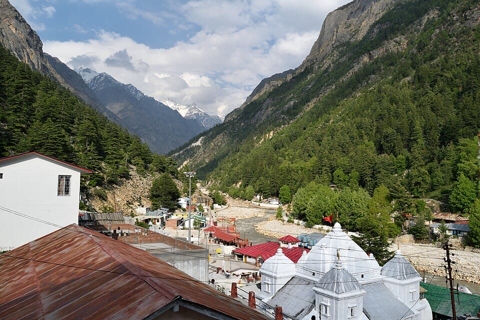
Uttarakhand, four valley roads from Rishikesh to the road heads for Yamunotri, Gangotri, Kedarnath and Badrinath
At the start, in Rishikesh, 1 km off the road.
From the open map · read 7 October 2026
At the start, in Rishikesh, 1 km off the road.
From the open map · read 7 October 2026
At the start, in Rishikesh, 1 km off the road.
From the open map · read 7 October 2026
At the start, in Rishikesh, 1 km off the road.
From the open map · read 7 October 2026
At the start, in Rishikesh, 1 km off the road.
From the open map · read 7 October 2026
At the start, in Rishikesh, 1 km off the road.
From the open map · read 7 October 2026
At the start, in Rishikesh, 1 km off the road.
From the open map · read 7 October 2026
At the start, in Rishikesh, 1 km off the road.
From the open map · read 7 October 2026
1 km from Rishikesh, 1 km off the road.
From the open map · read 7 October 2026
2 km from Rishikesh.
From the open map · read 7 October 2026
2 km from Rishikesh.
From the open map · read 7 October 2026
12 km from Rishikesh.
From the open map · read 7 October 2026
14 km from Rishikesh.
From the open map · read 7 October 2026
16 km from Rishikesh.
From the open map · read 7 October 2026
19 km from Rishikesh.
From the open map · read 7 October 2026
35 km from Rishikesh.
From the open map · read 7 October 2026
36 km from Rishikesh.
From the open map · read 7 October 2026
40 km from Rishikesh.
From the open map · read 7 October 2026
40 km from Rishikesh.
From the open map · read 7 October 2026
Indian Oil. 41 km from Rishikesh.
From the open map · read 7 October 2026
41 km from Rishikesh.
From the open map · read 7 October 2026
41 km from Rishikesh.
From the open map · read 7 October 2026
41 km from Rishikesh, 1 km off the road.
From the open map · read 7 October 2026
Indian Oil. 42 km from Rishikesh, 1 km off the road.
From the open map · read 7 October 2026
44 km from Rishikesh, 1 km off the road.
From the open map · read 7 October 2026
45 km from Rishikesh, 1 km off the road.
From the open map · read 7 October 2026
45 km from Rishikesh, 1 km off the road.
From the open map · read 7 October 2026
45 km from Rishikesh.
From the open map · read 7 October 2026
45 km from Rishikesh, 1 km off the road.
From the open map · read 7 October 2026
47 km from Rishikesh, 1 km off the road.
From the open map · read 7 October 2026
50 km from Rishikesh.
From the open map · read 7 October 2026
52 km from Rishikesh.
From the open map · read 7 October 2026
54 km from Rishikesh.
From the open map · read 7 October 2026
Indian Oil. 68 km from Rishikesh.
From the open map · read 7 October 2026
70 km from Rishikesh.
From the open map · read 7 October 2026
104 km from Rishikesh.
From the open map · read 7 October 2026
127 km from Rishikesh.
From the open map · read 7 October 2026
Indian Oil. 148 km from Rishikesh.
From locator.iocl.com · read 7 October 2026
HP. 154 km from Rishikesh.
From petrolpump.hpretail.in · read 7 October 2026
Indian Oil. 305 km from Rishikesh.
From locator.iocl.com · read 7 October 2026
312 km from Rishikesh.
From the open map · read 7 October 2026
HP. 327 km from Rishikesh.
From petrolpump.hpretail.in · read 7 October 2026
523 km from Rishikesh.
From the open map · read 7 October 2026
Indian Oil. 550 km from Rishikesh.
From locator.iocl.com · read 7 October 2026
558 km from Rishikesh.
From the open map · read 7 October 2026
Indian Oil. 563 km from Rishikesh.
From locator.iocl.com · read 7 October 2026
HP. 584 km from Rishikesh.
From petrolpump.hpretail.in · read 7 October 2026
Indian Oil. 608 km from Rishikesh.
From locator.iocl.com · read 7 October 2026
Indian Oil. 622 km from Rishikesh, 2 km off the road.
From locator.iocl.com · read 7 October 2026
Indian Oil. 628 km from Rishikesh, 1 km off the road.
From locator.iocl.com · read 7 October 2026
HP. 629 km from Rishikesh.
From petrolpump.hpretail.in · read 7 October 2026
HP. 645 km from Rishikesh.
From petrolpump.hpretail.in · read 7 October 2026
679 km from Rishikesh.
From the open map · read 7 October 2026
679 km from Rishikesh.
From the open map · read 7 October 2026
Indian Oil. 684 km from Rishikesh.
From locator.iocl.com · read 7 October 2026
691 km from Rishikesh.
From the open map · read 7 October 2026
716 km from Rishikesh.
From the open map · read 7 October 2026
HP. 729 km from Rishikesh.
From petrolpump.hpretail.in · read 7 October 2026
HP. 734 km from Rishikesh.
From petrolpump.hpretail.in · read 7 October 2026
HP. 759 km from Rishikesh.
From petrolpump.hpretail.in · read 7 October 2026
HP. 759 km from Rishikesh, 1 km off the road.
From petrolpump.hpretail.in · read 7 October 2026
Indian Oil. 761 km from Rishikesh, 1 km off the road.
From locator.iocl.com · read 7 October 2026
Indian Oil. 810 km from Rishikesh.
From locator.iocl.com · read 7 October 2026
Indian Oil. 817 km from Rishikesh.
From locator.iocl.com · read 7 October 2026
Indian Oil. 859 km from Rishikesh.
From locator.iocl.com · read 7 October 2026
Indian Oil. 864 km from Rishikesh.
From locator.iocl.com · read 7 October 2026
869 km from Rishikesh.
From the open map · read 7 October 2026
883 km from Rishikesh.
From the open map · read 7 October 2026
891 km from Rishikesh.
From the open map · read 7 October 2026
Indian Oil. 912 km from Rishikesh.
From locator.iocl.com · read 7 October 2026
Indian Oil. 917 km from Rishikesh.
From locator.iocl.com · read 7 October 2026
927 km from Rishikesh, 1 km off the road.
From the open map · read 7 October 2026
929 km from Rishikesh.
From the open map · read 7 October 2026
941 km from Rishikesh.
From the open map · read 7 October 2026
942 km from Rishikesh.
From the open map · read 7 October 2026
948 km from Rishikesh.
From the open map · read 7 October 2026
953 km from Rishikesh.
From the open map · read 7 October 2026
957 km from Rishikesh.
From the open map · read 7 October 2026
971 km from Rishikesh.
From the open map · read 7 October 2026
978 km from Rishikesh.
From the open map · read 7 October 2026
1,019 km from Rishikesh.
From the open map · read 7 October 2026
| Halt | ATMs | Banks |
|---|---|---|
| RishikeshAlankit, Axis Bank, Axis Bank ATM, Axis Bank Branch, Bandhan Bank, Bank of Baroda | 12 | 26 |
| Between Rishikesh and BarkotAavas Financiers Limited, Allahabad Bank, Almora Urban Cooperative Bank, Axis Bank, Axis Bank ATM, Axis Bank Branch | 36 | 83 |
| BarkotPunjab National Bank, Uttarakhand Gramin Bank, Uttarakhand Gramin Bank-Lakhmandal | 0 | 4 |
| Janki ChattiHDFC Bank ATM, Punjab National Bank | 1 | 1 |
| GangotriHDFC Bank ATM | 1 | 0 |
| UttarkashiAxis Bank ATM, Axis Bank Branch, Bank of Baroda, HDFC Bank, IndusInd Bank, Punjab National Bank | 1 | 11 |
| Between Uttarkashi and RudraprayagAxis Bank ATM, Axis Bank Branch, Bank of Baroda, HDFC Bank, HDFC Bank ATM, ICICI Bank | 6 | 19 |
| GuptkashiAxis Bank, Punjab National Bank - ATM | 1 | 1 |
| Between Sonprayag and RudraprayagPunjab National Bank | 0 | 1 |
| RudraprayagAxis Bank ATM, Bank of Baroda, HDFC Bank, HDFC Bank ATM, Indian Overseas Bank, IndusInd Bank | 3 | 8 |
| Between Rudraprayag and JoshimathAxis Bank ATM, Bank of Baroda, Chamoli Zila Sahkari Bank Limited, DK Electronics, HDFC Bank, HDFC Bank ATM | 3 | 14 |
| JoshimathAxis Bank, Bank of Baroda, HDFC Bank, Indian Overseas Bank, Punjab National Bank, Uttaranchal Gramin Bank-Helang | 0 | 6 |
| BadrinathHDFC Bank ATM, Punjab National Bank - ATM | 2 | 0 |
Listed on a public map (Overture Maps). An ATM on the map can be empty or out of order, and no rider has confirmed these yet.
Registration is compulsory and free on the state tourism board's portal, for every traveller and vehicle, before setting out. The portal does not single out two-wheelers.
From registrationandtouristcare.uk.gov.in · dated 27 September 2026 · read 28 September 2026
Commercial vehicles need a green card and a trip card. Private vehicles are registered on the same portal, user charge Rs 50. Trip validity is ten days for four shrines.
From greencard.uk.gov.in · read 28 September 2026
News reports say vehicles may not move on the mountain routes from 22:00 to 04:00. An earlier operator report gave 20:00 to 05:00. The order itself was not found.
No government order found · from outlooktraveller.com · dated 21 April 2026 · read 28 September 2026
Dates follow the Hindu calendar. Closing dates are declared on Vijayadashami, Badrinath's opening on Basant Panchami and Kedarnath's opening on Mahashivratri.
From indiatvnews.com · dated 12 October 2024 · read 28 September 2026
When the weather office issues a red alert, the registration portal posts that the yatra is suspended for that date.
From registrationandtouristcare.uk.gov.in · dated 27 September 2026 · read 28 September 2026
Vehicles from other states pay a green cess on entry, read by number-plate cameras at the border. Two-wheelers, electric and gas vehicles are exempt. Official order not found.
No government order found · from etvbharat.com · dated 14 January 2026 · read 28 September 2026
Between Srinagar and Rudraprayag. It has blocked the Badrinath highway in the monsoon for close to thirty years.
From etvbharat.com · dated 2 July 2026 · read 28 September 2026
In Chamoli district. Heavy rain shut the highway here for thirteen hours in July 2023.
From tribuneindia.com · dated 2 July 2023 · read 28 September 2026
Researchers counted 164 landslides between Rishikesh and Badrinath after the road was widened.
From scroll.in · dated 9 January 2026 · read 28 September 2026
The yatra is halted for the day when a red alert is issued, as on 27 September 2026.
From registrationandtouristcare.uk.gov.in · dated 27 September 2026 · read 28 September 2026
The road above the last towns is generally closed from December to March.
From en.wikipedia.org · read 28 September 2026
After the 2026 monsoon, debris still narrows the road near Nagun bridge, Dharasu Band and Nalupani, and stones fall. The BRO has ordered it cleared.
From amarujala.com · dated 14 October 2026 · read 15 October 2026
Not listed: Rishikesh (20 shops on the map). This list is for the halts between, where repair shops are few.
Tyres and punctures
From the open map · dated 22 October 2026 · read 8 November 2026
Motorcycle repair
From the open map · dated 22 October 2026 · read 8 November 2026
Vehicle repair
From the open map · dated 22 October 2026 · read 8 November 2026
Tyres and punctures
From the open map · dated 22 October 2026 · read 8 November 2026
Vehicle repair
From the open map · dated 22 October 2026 · read 8 November 2026
Vehicle repair
From the open map · dated 22 October 2026 · read 8 November 2026
Not listed: Rishikesh (293 places on the map), Uttarkashi (116 places on the map), Joshimath (99 places on the map), Guptkashi (84 places on the map), Rudraprayag (81 places on the map), Barkot (54 places on the map), Badrinath (44 places on the map), Sonprayag (44 places on the map). This list is for the halts between, where rooms are few.
Hotel
From the open map · dated 22 October 2026 · read 8 November 2026
Hotel
From the open map · dated 22 October 2026 · read 8 November 2026
Resort
From the open map · dated 22 October 2026 · read 8 November 2026
Resort
From the open map · dated 22 October 2026 · read 8 November 2026
Cottage
From the open map · dated 22 October 2026 · read 8 November 2026
Hotel
From the open map · dated 22 October 2026 · read 8 November 2026
Resort
From the open map · dated 22 October 2026 · read 8 November 2026
Hotel
From the open map · dated 22 October 2026 · read 8 November 2026
Resort
From the open map · dated 22 October 2026 · read 8 November 2026
Resort
From the open map · dated 22 October 2026 · read 8 November 2026
Hotel
From the open map · dated 22 October 2026 · read 8 November 2026
Resort
From the open map · dated 22 October 2026 · read 8 November 2026
Lodging
From the open map · dated 22 October 2026 · read 8 November 2026
Hotel
From the open map · dated 22 October 2026 · read 8 November 2026
Hotel, 3.0 km off the road
From the open map · dated 22 October 2026 · read 8 November 2026
Cottage
From the open map · dated 22 October 2026 · read 8 November 2026
Hotel
From the open map · dated 22 October 2026 · read 8 November 2026
Resort
From the open map · dated 22 October 2026 · read 8 November 2026
Hotel
From the open map · dated 22 October 2026 · read 8 November 2026
Hotel
From the open map · dated 22 October 2026 · read 8 November 2026
Hotel
From the open map · dated 22 October 2026 · read 8 November 2026
Hotel
From the open map · dated 22 October 2026 · read 8 November 2026
Lodging
From the open map · dated 22 October 2026 · read 8 November 2026
Homestay
From the open map · dated 22 October 2026 · read 8 November 2026
Hotel
From the open map · dated 22 October 2026 · read 8 November 2026
Hotel
From the open map · dated 22 October 2026 · read 8 November 2026
Hotel
From the open map · dated 22 October 2026 · read 8 November 2026
Hotel
From the open map · dated 22 October 2026 · read 8 November 2026
Homestay
From the open map · dated 22 October 2026 · read 8 November 2026
Hotel
From the open map · dated 22 October 2026 · read 8 November 2026
Hotel
From the open map · dated 22 October 2026 · read 8 November 2026
Lodging
From the open map · dated 22 October 2026 · read 8 November 2026
Hotel
From the open map · dated 22 October 2026 · read 8 November 2026
Hotel
From the open map · dated 22 October 2026 · read 8 November 2026
Cottage
From the open map · dated 22 October 2026 · read 8 November 2026
Resort
From the open map · dated 22 October 2026 · read 8 November 2026
A trip report takes about three minutes. It fills in mobile network, real riding hours, bikes riders took and what the trip cost for the next rider. Or tap “Still true” on any fact you saw yourself.
Send a trip report