1 km from Sunauli.
Nepal: Pokhara, Mustang and Muktinath
Basic page · 89 facts
NH 47
367KM
Nepal: Pokhara, Mustang and Muktinath
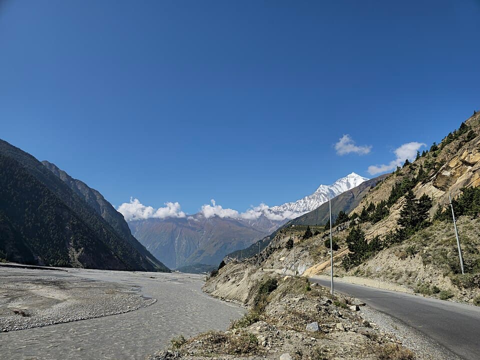
Nepal from the border at Sunauli up the Siddhartha Highway to Pokhara, then the Kali Gandaki valley to Jomsom and Muktinath
- Highest point
- 12,340 ft
- Usually open
- Spring, and Oct to Nov; the monsoon runs Jun to Sept
- No fuel for
- 74 km
This is a basic page
No rider has reported on this route yet. What is here comes from official and published sources. How far to trust it
Before you leave
On this page
Fuel
57 pumpsSunauli0 kmMuktinath367 km74 km · no pumpButwal100 km
From the open map, not yet checked
All 57 pumps were read from OpenStreetMap on 28 September 2026. No rider has confirmed any of them yet.
5 km from Sunauli.
6 km from Sunauli.
6 km from Sunauli, 1 km off the road.
6 km from Sunauli, 1 km off the road.
6 km from Sunauli, 1 km off the road.
6 km from Sunauli.
6 km from Sunauli.
Show 49 more pumps
6 km from Sunauli.
7 km from Sunauli.
7 km from Sunauli.
8 km from Sunauli.
11 km from Sunauli, 1 km off the road.
16 km from Sunauli, 1 km off the road.
16 km from Sunauli, 1 km off the road.
16 km from Sunauli, 1 km off the road.
16 km from Sunauli, 1 km off the road.
16 km from Sunauli, 1 km off the road.
17 km from Sunauli, 1 km off the road.
18 km from Sunauli, 1 km off the road.
19 km from Sunauli, 1 km off the road.
21 km from Sunauli.
24 km from Sunauli.
Milan Brothers Petrol Pump, near Butwal
Last fuel for 74 km26 km from Sunauli, 1 km off the road.
Petrol pump, near Butwal
First fuel after the gap100 km from Sunauli.
102 km from Sunauli.
120 km from Sunauli.
129 km from Sunauli.
155 km from Sunauli.
178 km from Sunauli.
180 km from Sunauli.
180 km from Sunauli.
182 km from Sunauli.
182 km from Sunauli.
National Trading Limited. 183 km from Sunauli.
183 km from Sunauli.
183 km from Sunauli, 1 km off the road.
183 km from Sunauli, 1 km off the road.
183 km from Sunauli, 1 km off the road.
184 km from Sunauli.
185 km from Sunauli.
185 km from Sunauli.
Armed Police Force (APF). 186 km from Sunauli.
186 km from Sunauli.
187 km from Sunauli.
188 km from Sunauli.
188 km from Sunauli.
private. 188 km from Sunauli.
189 km from Sunauli.
189 km from Sunauli.
193 km from Sunauli.
194 km from Sunauli.
195 km from Sunauli.
228 km from Sunauli.
237 km from Sunauli.
250 km from Sunauli.
319 km from Sunauli.
Rules for motorcycles
7 factsNepal: customs pass for an Indian-registered vehicle
Not yet checkedIssued by Nepal Customs at the border for a stated number of days, two-wheelers included. The Indian embassy gives the charge as 100 to 500 Nepalese rupees a day.
From indembkathmandu.gov.in · dated 28 September 2026 · read 28 September 2026 · no rider has confirmed it
Nepal: 30 days a year for an Indian vehicle
Not yet checkedAn Indian-registered vehicle may stay 30 days in total in a calendar year. An extension must be sought at a Nepal Customs office before the pass expires.
From indembkathmandu.gov.in · dated 28 September 2026 · read 28 September 2026 · no rider has confirmed it
Nepal: free day pass only to the nearest market
Not yet checkedA day pass lets a vehicle visit the nearest town without customs charge. It must return to India the same day and hand the pass back.
From indembkathmandu.gov.in · dated 28 September 2026 · read 28 September 2026 · no rider has confirmed it
Nepal: vehicle without a valid pass is seized
Not yet checkedA vehicle found without a pass, or with an expired one, is treated as smuggled, confiscated and later auctioned by Nepal Customs.
From indembkathmandu.gov.in · dated 28 September 2026 · read 28 September 2026 · no rider has confirmed it
Nepal: passport or original voter card
Not yet checkedFor air travel the embassy accepts only a passport or an original voter identity card; Aadhaar and driving licence are refused. The page does not cover land crossings.
From indembkathmandu.gov.in · dated 28 September 2026 · read 28 September 2026 · no rider has confirmed it
Annapurna Conservation Area: entry permit
Not yet checkedCosts 1,000 Nepalese rupees for citizens of South Asian countries and 3,000 for other foreigners. Single entry; bought online or at a counter; shown at check posts.
From epermit.ntnc.org.np · dated 2026 · read 28 September 2026 · no rider has confirmed it
Upper Mustang: restricted area permit, 50 dollars a day
Not yet checkedCovers Lomanthang and Lo-Ghekar Damodarkunda, plus ward 3 and Satang village of Baragung Muktichhetra. Issued by the immigration department in Kathmandu. Needed only beyond this route.
From ntb.gov.np · read 28 September 2026 · no rider has confirmed it
Trouble on the road
4 warningsFrom published guides, not from riders
Each warning names the months it applies to. None has been seen by a rider this season unless it says so.
Rockfall between Butwal and Palpa
Not yet checkedWikipedia describes this section of the Siddhartha Highway as rocky, with frequent rockfall that sometimes causes fatal accidents.
From en.wikipedia.org · dated 14 September 2026 · read 28 September 2026 · no rider has confirmed it
Monsoon rain south of the Himalaya
Not yet checkedThe tourism board says four-fifths of Nepal's rain falls from June to September. Mustang itself lies in a rain shadow and stays dry.
From ntb.gov.np · read 28 September 2026 · no rider has confirmed it
Strong daily wind in the Kali Gandaki valley
Not yet checkedWind blowing up the valley is strong enough to stop flights from Jomsom after about 11 in the morning.
From en.wikipedia.org · dated 27 September 2026 · read 28 September 2026 · no rider has confirmed it
Road works on the Kali Gandaki corridor
Not yet checkedWikipedia lists the highway through Beni and Kagbeni as under construction since December 2018, with its completion status unclear.
From en.wikipedia.org · dated 9 April 2026 · read 28 September 2026 · no rider has confirmed it
Videos
Watch the date, not the view
Each video shows the road as it was that month. They play on YouTube, under the maker’s own channel.
Sunauli to Muktinath
367 kmNo video of this stretch yetFilmed it? Send the link. It plays on YouTube, with your name and the month.Add a video
Not here yet
Mechanics and puncture repair
Mobile network
Real riding hours
Stays
These come from riders, not from us
They appear when riders who have done this route send a trip report. It takes about three minutes.
What a trip report asks
Route, month and bikeNeeded
Riding hours, fuel stops, mechanics, gear, cost, a videoOptional. Fill in what you remember.
Bikes, gear and costs show after 10 trip reportsWith fewer, this would be a handful of opinions, not a pattern.
0 of 10 reports
0 trip reports for Nepal: Pokhara, Mustang and Muktinath so far
Also
0 trip reports for Nepal: Pokhara, Mustang and Muktinath so far
Ridden it? Send a trip report