At the start, in Manali, 1 km off the road.
From the open map · read 6 October 2026
176 facts
Himachal Pradesh to Ladakh through the Atal Tunnel, over Baralacha La and Tanglang La
At the start, in Manali, 1 km off the road.
From the open map · read 6 October 2026
2 km from Manali.
From the open map · read 6 October 2026
3 km from Manali.
From the open map · read 6 October 2026
Indian Oil. 41 km from Manali.
From locator.iocl.com · read 6 October 2026
61 km from Manali.
From the open map · read 6 October 2026
73 km from Manali.
From the open map · read 6 October 2026
Indian Oil. 402 km from Manali.
From the open map · read 6 October 2026
Indian Oil. 416 km from Manali, 2 km off the road.
From locator.iocl.com · read 6 October 2026
428 km from Manali.
From the open map · read 6 October 2026
431 km from Manali.
From the open map · read 6 October 2026
432 km from Manali.
From the open map · read 6 October 2026
At the end of the route, 1 km off the road.
From the open map · read 6 October 2026
| Halt | ATMs | Banks |
|---|---|---|
| ManaliAxis Bank, Bank of Baroda, HDFC Bank, ICICI Bank, J&K Bank, Jammu and Kashmir Bank ATM | 2 | 11 |
| SissuState Bank of India ATM | 1 | 0 |
| KeylongHDFC Bank ATM, ICICI Bank, Punjab National Bank | 1 | 2 |
| UpshiJ&K Bank | 0 | 1 |
| KaruATM, Bank, Punjab National Bank | 1 | 2 |
| LehAxis Bank, Axis Bank ATM, Axis Bank Branch, Bank of Baroda, HDFC Bank, HDFC Bank ATM | 6 | 15 |
Listed on a public map (Overture Maps). An ATM on the map can be empty or out of order, and no rider has confirmed these yet.
Indian citizens carry identity proof and the fee receipt instead of a permit. A few border villages stay closed. The order itself was not found; news reports it.
From freepressjournal.in · dated 7 August 2021 · read 28 September 2026
One payment covers an environment fee, a Red Cross contribution and a wildlife fee. The official portal does not show the amounts on its landing page.
From lahdclehpermit.in · read 28 September 2026
The highway needs no Protected Area Permit; passports are checked at the Koksar police post. Side trips beyond Leh need the permit. No written order found.
No government order found · from en.wikipedia.org · read 28 September 2026
Needed for Nubra, Pangong, Tso Moriri and similar areas beyond Leh. Some nationalities and passport types must apply to central ministries instead.
From lahdclehpermit.in · read 28 September 2026
Outside rentals may reach Leh but not tour Nubra, Pangong or Hanle. Enforced by the local rental cooperative; no government order found. Own motorcycles are fine with papers.
No government order found · from tribuneindia.com · dated 26 May 2023 · read 28 September 2026
Issued only through the Kullu district portal, with no cancellation once issued. The official pages opened do not state fees, quotas or any two-wheeler rule.
From rohtangpermits.hp.gov.in · read 28 September 2026
Riders to Lahaul and Leh use the tunnel and skip Rohtang. No official page was found saying so; operator guides say no Rohtang permit is needed for the tunnel.
No government order found · from milemarked.com · dated 15 May 2026 · read 28 September 2026
Every vehicle entering Lahaul and Spiti, motorcycles included, applies online: an e-permit for the Atal Tunnel–Koksar–Chandratal circuit, an e-ticket elsewhere. Whether motorcycles pay was not confirmed.
From eaagman.hp.gov.in · read 17 October 2026
Charged on tourist vehicles, two-wheelers included, valid seven days, collected at an automated barrier. No order was found, nor how motorcycles without an electronic tag pay.
No government order found · from tribuneindia.com · dated 10 February 2022 · read 28 September 2026
Police at Darcha limit travel beyond it in snow; in spring 2026 only 4x4s went to Shinku La, 9 am to 1 pm. Registration here is reported, without an order.
No government order found · from hplahaulspiti.nic.in · read 17 October 2026
When the road first opens, the district allows light vehicles first and holds two-wheelers and trucks until Baralacha La is judged safe.
From tribuneindia.com · dated 25 April 2022 · read 28 September 2026
At the start and end of the season traffic must pass Darcha or Sarchu within set hours, sometimes one direction per day. The hours change every year.
From tribuneindia.com · dated 19 November 2024 · read 28 September 2026
The Lahaul and Spiti district closes the road beyond Darcha on the road builder's advice. Ladakh Police issue a separate notice for their side.
From etvbharat.com · dated 18 November 2025 · read 28 September 2026
Melt water runs across the road around the pass, with slush early in the season.
From discoverwithdheeraj.com · dated 11 September 2026 · read 28 September 2026
The pass has closed again for days after opening, including an avalanche on 15 April 2021 that stranded travellers.
From discoverwithdheeraj.com · dated 31 July 2026 · read 28 September 2026
A flash flood on 30 June 2026 closed the road near Jispa until debris was cleared the same day.
From discoverwithdheeraj.com · dated 31 July 2026 · read 28 September 2026
Described as the roughest stretch of the highway every year.
From discoverwithdheeraj.com · dated 11 September 2026 · read 28 September 2026
Keylong is described as the last pump before a long gap; the next pump the source lists is at Karu.
From discoverwithdheeraj.com · dated 25 September 2026 · read 28 September 2026
A blogger reports that only postpaid connections from outside work in Jammu and Kashmir and in Ladakh; no official source was found.
From discoverwithdheeraj.com · dated 14 August 2026 · read 28 September 2026
Signal drops after Darcha. Sarchu got one network in 2021; beyond it towards Pang and Tanglang La there is none.
From discoverwithdheeraj.com · dated 14 August 2026 · read 28 September 2026
Shaded stretches near the high passes ice over from early October, and riding after mid-October is described as risky.
From discoverlehladakh.in · dated 9 June 2026 · read 28 September 2026
Police stopped traffic over Baralacha La after snow on 11 October 2026. On 15 October Darcha to Sarchu was listed as closed by snow, with no reopening time.
From amarujala.com · dated 15 October 2026 · read 15 October 2026


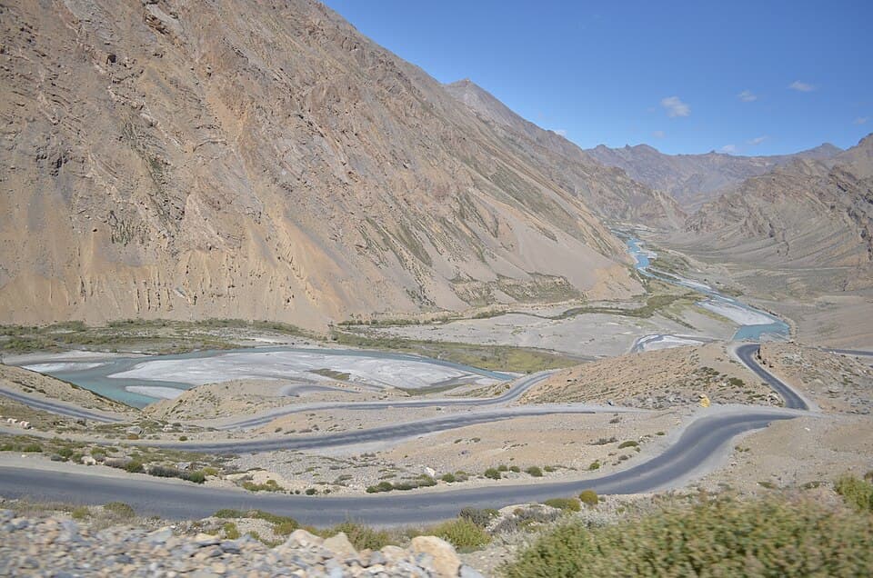
From Wikimedia Commons, the newest dated photo near each pass and high halt. A photo shows the road on the day it was taken, not today.
Showroom and service centre
From the open map · dated 22 October 2026 · read 8 November 2026
Tyres and punctures, 1.4 km off the road
From the open map · dated 22 October 2026 · read 8 November 2026
Motorcycle repair, 1.1 km off the road
From the open map · dated 22 October 2026 · read 8 November 2026
Vehicle repair
From the open map · dated 22 October 2026 · read 8 November 2026
Showroom and service centre
From the open map · dated 22 October 2026 · read 8 November 2026
Showroom and service centre
From the open map · dated 22 October 2026 · read 8 November 2026
Tyres and punctures
From the open map · dated 22 October 2026 · read 8 November 2026
Showroom and service centre
From the open map · dated 22 October 2026 · read 8 November 2026
Motorcycle repair
From the open map · dated 22 October 2026 · read 8 November 2026
Motorcycle repair
From the open map · dated 22 October 2026 · read 8 November 2026
Motorcycle repair
From the open map · dated 22 October 2026 · read 8 November 2026
Not listed: Manali (1,517 places on the map), Leh (435 places on the map). This list is for the halts between, where rooms are few.
Lodging
From the open map · dated 22 October 2026 · read 8 November 2026
Homestay
From the open map · dated 22 October 2026 · read 8 November 2026
Hotel
From the open map · dated 22 October 2026 · read 8 November 2026
Resort
From the open map · dated 22 October 2026 · read 8 November 2026
Hotel
From the open map · dated 22 October 2026 · read 8 November 2026
Campsite
From the open map · dated 22 October 2026 · read 8 November 2026
Hotel
From the open map · dated 22 October 2026 · read 8 November 2026
Homestay
From the open map · dated 22 October 2026 · read 8 November 2026
Hotel
From the open map · dated 22 October 2026 · read 8 November 2026
Campsite
From the open map · dated 22 October 2026 · read 8 November 2026
Hotel
From the open map · dated 22 October 2026 · read 8 November 2026
Campsite
From the open map · dated 22 October 2026 · read 8 November 2026
Lodging
From the open map · dated 22 October 2026 · read 8 November 2026
Hotel
From the open map · dated 22 October 2026 · read 8 November 2026
Hotel, 1.7 km off the road
From the open map · dated 22 October 2026 · read 8 November 2026
Homestay
From the open map · dated 22 October 2026 · read 8 November 2026
Homestay
From the open map · dated 22 October 2026 · read 8 November 2026
Homestay
From the open map · dated 22 October 2026 · read 8 November 2026
Lodging
From the open map · dated 22 October 2026 · read 8 November 2026
Homestay
From the open map · dated 22 October 2026 · read 8 November 2026
Homestay
From the open map · dated 22 October 2026 · read 8 November 2026
Homestay
From the open map · dated 22 October 2026 · read 8 November 2026
Campsite
From the open map · dated 22 October 2026 · read 8 November 2026
Hotel
From the open map · dated 22 October 2026 · read 8 November 2026
Campsite
From the open map · dated 22 October 2026 · read 8 November 2026
Campsite
From the open map · dated 22 October 2026 · read 8 November 2026
Cottage
From the open map · dated 22 October 2026 · read 8 November 2026
Homestay
From the open map · dated 22 October 2026 · read 8 November 2026
Lodging
From the open map · dated 22 October 2026 · read 8 November 2026
Homestay
From the open map · dated 22 October 2026 · read 8 November 2026
Hotel
From the open map · dated 22 October 2026 · read 8 November 2026
Lodging
From the open map · dated 22 October 2026 · read 8 November 2026
Homestay
From the open map · dated 22 October 2026 · read 8 November 2026
Guest house
From the open map · dated 22 October 2026 · read 8 November 2026
Campsite
From the open map · dated 22 October 2026 · read 8 November 2026
Campsite
From the open map · dated 22 October 2026 · read 8 November 2026
Hotel
From the open map · dated 22 October 2026 · read 8 November 2026
Hotel
From the open map · dated 22 October 2026 · read 8 November 2026
Homestay
From the open map · dated 22 October 2026 · read 8 November 2026
Guest house
From the open map · dated 22 October 2026 · read 8 November 2026
Campsite
From the open map · dated 22 October 2026 · read 8 November 2026
Campsite
From the open map · dated 22 October 2026 · read 8 November 2026
Hotel
From the open map · dated 22 October 2026 · read 8 November 2026
Lodging
From the open map · dated 22 October 2026 · read 8 November 2026
Hotel
From the open map · dated 22 October 2026 · read 8 November 2026
Hotel
From the open map · dated 22 October 2026 · read 8 November 2026
Homestay
From the open map · dated 22 October 2026 · read 8 November 2026
Hotel
From the open map · dated 22 October 2026 · read 8 November 2026
Guest house
From the open map · dated 22 October 2026 · read 8 November 2026
Guest house
From the open map · dated 22 October 2026 · read 8 November 2026
Resort
From the open map · dated 22 October 2026 · read 8 November 2026
Guest house
From the open map · dated 22 October 2026 · read 8 November 2026
Hotel
From the open map · dated 22 October 2026 · read 8 November 2026
Hotel
From the open map · dated 22 October 2026 · read 8 November 2026
Hotel
From the open map · dated 22 October 2026 · read 8 November 2026
Hotel, 2.0 km off the road
From the open map · dated 22 October 2026 · read 8 November 2026
Hotel
From the open map · dated 22 October 2026 · read 8 November 2026
Campsite
From the open map · dated 22 October 2026 · read 8 November 2026
Campsite
From the open map · dated 22 October 2026 · read 8 November 2026
Hotel
From the open map · dated 22 October 2026 · read 8 November 2026
Hotel
From the open map · dated 22 October 2026 · read 8 November 2026
Cottage
From the open map · dated 22 October 2026 · read 8 November 2026
Hotel
From the open map · dated 22 October 2026 · read 8 November 2026
Campsite
From the open map · dated 22 October 2026 · read 8 November 2026
Homestay
From the open map · dated 22 October 2026 · read 8 November 2026
Lodging
From the open map · dated 22 October 2026 · read 8 November 2026
Campsite
From the open map · dated 22 October 2026 · read 8 November 2026
Resort
From the open map · dated 22 October 2026 · read 8 November 2026
Hotel
From the open map · dated 22 October 2026 · read 8 November 2026
Campsite
From the open map · dated 22 October 2026 · read 8 November 2026
Hotel
From the open map · dated 22 October 2026 · read 8 November 2026
Campsite
From the open map · dated 22 October 2026 · read 8 November 2026
Campsite
From the open map · dated 22 October 2026 · read 8 November 2026
Campsite
From the open map · dated 22 October 2026 · read 8 November 2026
Hotel, 2.5 km off the road
From the open map · dated 22 October 2026 · read 8 November 2026
Campsite
From the open map · dated 22 October 2026 · read 8 November 2026
Hotel
From the open map · dated 22 October 2026 · read 8 November 2026
Guest house
From the open map · dated 22 October 2026 · read 8 November 2026
Guest house
From the open map · dated 22 October 2026 · read 8 November 2026
Resort, 1.0 km off the road
From the open map · dated 22 October 2026 · read 8 November 2026
Campsite, 1.8 km off the road
From the open map · dated 22 October 2026 · read 8 November 2026
Homestay
From the open map · dated 22 October 2026 · read 8 November 2026
A trip report takes about three minutes. It fills in mobile network, real riding hours, bikes riders took and what the trip cost for the next rider. Or tap “Still true” on any fact you saw yourself.
Send a trip report